A. Delegation of Power: The Governing Body is hereby authorized to decide whether special use permits shall be granted subject to the general and specific standards contained in the ordinance; to grant special use permits with such conditions or restrictions as are appropriate to protect the public interest and to secure compliance with these regulations; and to deny requests which fail to satisfy the standards and requirements contained herein and which are not in harmony with the purposes and interest of these regulations and the health, safety, and welfare of the community. The Governing Body shall decide whether special use permits shall be granted only after having received a recommendation from the Planning Commission. In no event shall a special use permit be granted where the proposed use is not authorized by the terms of these regulations, or where the standards of this article are not found to exist.
B. Conditions and Guarantees: Prior to the granting of any special use permit, the Planning Commission or Governing Body may stipulate such conditions and restrictions upon the establishment, location, construction, maintenance and operation of the special use permit as is deemed necessary for the protection of the public interest and to secure compliance with the standards and conditions contained herein. In all cases in which a special use permit is granted, the Planning Commission may recommend or the Governing Body may require such evidence and guarantees as may be deemed necessary to ensure that the conditions stipulated are being, and will be, fully complied with.
C. Special Use Permits in Residential Districts: In no event shall special use permits in residential districts be transferable from an owner-applicant to a subsequent owner of the subject real estate or structure.
A. Application: A written application for a special use permit shall be filed with the Planning and Zoning Department and shall include a statement indicating the section of the ordinance under which the permit is sought, the grounds upon which it is requested, and sufficient evidence to show that the use will conform to the standards set forth. The application shall be accompanied by an area map and site plan of the subject property.
B. Fees: Every application for a special use permit shall be subject to a filing fee as established by the Governing Body.
C. Site Plan: All applicants for special use permit shall submit with their application copies of a development plan for the property in accordance with the City’s Application and Review Schedule and the requirements of Article 11, Site Plan Review.
D. Hearing: Upon receipt of the formal application and all accompanying material, the Planning and Zoning Department shall call a public hearing for the next scheduled meeting of the Planning Commission; provided, however, that notice must be published in the same manner required for a zoning district amendment as directed in Article 13, Section 3 Public Notice. The Planning Commission shall submit a recommendation to their Governing Body within 30 days after the close of the public hearing. (Ord. 2049)
E. Findings: In making a recommendation to the Governing Body, the Planning Commission shall specify the particular grounds relied upon and their relation to the proposed use and shall make affirmative findings that the proposed use conforms with the general standards set forth in this article. In no case shall an exception be granted if the proposed use will constitute a nuisance or a public health or safety hazard to adjacent properties or to the community at large.
F. Action by Governing Body: The Governing Body shall consider the Planning Commission’s recommendation at the next regularly scheduled Governing Body meeting for which the agenda item can be docketed. The Governing Body shall consider the recommendation of the Planning Commission and act in accordance with the procedures for amending zoning district boundaries. If the Governing Body fails to act upon a recommendation within 120 days from the receipt thereof, the application shall be deemed to have been denied.
In order to recommend approval or disapproval of a proposed special use permit, the Planning Commission and Governing Body shall determine whether the proposed use is found to be generally compatible with surrounding development and is in the best interest of the City. In making such determination, the Planning Commission and Governing Body may consider all factors they deem relevant to the questions of compatibility and the best interest of the City, including the following: (Ord.2056 Amends entire section, adding G-J below)
A. The character of the neighborhood, including but not limited to: zoning, existing and approved land use, platting, density (residential), natural features, and open space.
B. The nature and intensity of the proposed use and its compatibility with the zoning and uses of nearby properties. Such determination should include the location, nature, and height of structures, walls, fences, and other improvements connected with the proposed use, their relation to adjacent property and uses, and the need for buffering or screening.
C. The extent to which there is a need in the community for the proposed use.
D. The availability and adequacy of required utilities and services to serve the proposed use. These utilities and services include, but are not limited to, sanitary and storm sewers, water, electrical and gas service, police and fire protection, schools, parks and recreation facilities and services, and other similar public facilities and services.
E. The adequacy of ingress and egress to and within the site of the proposed use, traffic flow and control, the adequacy of off-street parking and loading areas, the adequacy of required yard and open space requirements and sign provisions.
F. The extent to which the proposed use would adversely affect the capacity or safety of that portion of the street network influenced by the proposed use, or present parking problems in the vicinity of the property.
G. The environmental impacts that the proposed use would create (if any) including, but not limited to, excessive storm water runoff, water pollution, air pollution, noise pollution, excessive nighttime lighting or other environmental harm.
H. The economic impact of the proposed use on the community.
I. The extent to which the proposed use may detrimentally affect nearby property.
J. The relative gain (if any) to the public health, safety, and welfare from a denial of the application for special use permit as compared to the hardship imposed upon the special use applicant from such denial.
K. Consistency with the Comprehensive Plan, Utilities and Facilities Plans, Capital Improvement Plan, Area Plans, ordinances, policies, and applicable City Code of the City of De Soto, and the general safety, health, comfort and general welfare of the community.
L. The recommendation of professional staff.
In granting a special use, the City may impose such conditions, safeguards and restrictions upon the premises to reduce or minimize any potential injurious effect of such special uses upon other property in the neighborhood, and to carry out the general purpose and intent of these regulations. The following additional conditions shall be requirements for the approval of the following special uses:
A. Day care centers shall obtain a special use permit for the care of more than six children in zoning districts permitting residents, provided that:
(1) One off-street parking space is provided for each non-resident or non-family member employee, in addition to the two spaces per single-family dwelling or duplex dwelling unit required. The residential driveway is acceptable for this purpose.
(2) If located on an arterial or collector street, an off-street drop-off/pick-up area must be provided.
(3) The requirements for accessory uses for the proposed day care home are met.
B. Auto wrecking yards, junk yards, salvage yards, and scrap processing yards:
(1) Shall be located at least 300 feet from a residential district zone.
(2) The operation shall be conducted wholly within a noncombustible structure or within an area completely enclosed by a fence or wall at least eight feet high. The fence or wall shall be of uniform height, color and texture, and shall be maintained in good condition by the property owner. No scrap, junk or other salvaged materials shall be piled to exceed the height of this wall or fence.
(3) No junk or salvaged material shall be loaded, unloaded or stored, either temporarily or permanently, outside the enclosed structure, fence or wall.
(4) Burning of paper, trash, junk or other waste materials shall be permitted only after approval of the Fire Department, except when prohibited by the Kansas Department of Health and Environment.
C. Funeral, mortuary or crematory services shall be located on a collector or arterial street as shown on the Comprehensive Plan.
D. Wind-powered generating systems shall conform to the following standards: (Ord. 2244 Amends and expands section)
(1) The goal of these regulations is to help residents and businesses reduce dependence upon energy providers, decrease pollution caused by conventional energy sources, reduce peak power demands and help to diversify the overall energy supply needs for the City while offsetting the visual impact of such systems upon the surrounding properties and the City as a whole.
(2) Special Use Permit Required.
(a) A Special Use Permit shall be required for a private WECS or facility if it is expected to exceed the requirements set forth in Section 15, Article 5, Supplementary Height and Use Regulations.
(b) These regulations are not considered sufficient for the regulation of utility level energy systems or facilities. Such systems shall be examined on a case by case basis and regulated according to their benefit to the community and the need to mitigate the impact of such facility upon the community.
(3) System Heights
(a) The maximum height shall be the minimum height necessary for the tower to operate efficiently, but no more than two hundred (200’) feet. When considering height, the Planning Commission shall examine such issues as:
(i) Any regulations imposed by the Federal Aviation Administration (FAA) regarding air facilities in the area;
(ii) Wind height requirements as verified by wind surveys
(iii) Land forms, obstructions and other site specific impediments.
(iv) The zoning and use of the site and surrounding area.
(b) In no case shall the proposed height exceed the height recommended by the manufacturer or distributor of the system.
(c) The minimum height of the lowest sweep of the blades shall be at least 12 feet above average ground level.
(4) Setbacks. The system tower shall be no closer to the property line than the total height of the system and no part of the system, including guy wire anchors, may extend closer than 10 feet to the property boundary. No part of the system shall be located in any required front or side yard.
(5) Security and Safety.
(a) Guy wires must be marked and clearly visible to a height of six feet above the guy wire anchors. To prevent the loosening of the guy wires as a result of vibration or vandalism, safety wires shall be installed on the turnbuckles of the guy wires.
(b) The system shall contain a braking device for winds in excess of 40 m.p.h.
(c) At least one, very legible sign shall be posted at the base of a WECS, or on the gate of a fence, if required, and shall contain a warning of high voltage, an emergency phone number, and emergency shutdown procedures.
(d) Property owner shall maintain sufficient liability insurance coverage for the system and be able to produce proof of such upon request.
(6) Nuisance.
(a) Decibel levels for the system shall not exceed those established by Article 8 of Chapter 8 of the City Code as measured at the property line, except during short-term events such as utility outages and severe windstorms. Exceptions to these levels may be granted as part of the permit conditions.
(b) The system shall not cause or intensify interference to radio, television or other communications reception on nearby properties.
(7) Design. The application shall include standard signed and sealed drawings and an engineering analysis of the system’s tower prepared by a licensed professional mechanical, structural or civil engineer registered in the State of Kansas. This analysis may be supplied by the manufacturer.
(8) FAA Requirements. The system shall comply with all applicable Federal Aviation Administration requirements. Individual wind turbine lighting and markings shall comply with but not exceed FAA requirements. If lighting of turbines or other structures is required, “daytime white/nighttime red” shall be required. All required tower lighting shall be shielded from the ground and area residences.
(9) Construction and maintenance.
(a) A Building Permit is required prior to beginning of construction activities. All Building Permit applications shall be accompanied by the approved site plan and information from the Special Use Permit.
(b) All wind energy facilities shall be constructed according to manufacturer’s specifications.
(c) A certificate of completion provided by a licensed electrical contractor shall be provided certifying that all electrical work for the installation has been completed in accordance with the manufacturer’s specifications and the adopted electrical code for the City of De Soto.
(d) Wind facilities shall be required to meet any applicable flood plain requirements.
(e) Construction and operation shall be done in a manner so as to minimize soil erosion and other negative effects upon the environment.
(f) Systems shall be maintained according to manufacturer’s recommendations.
(g) Any energy system that will be connected to a utility grid must meet the standards of that utility and provide proof of compliance to the Building Official.
(10) Appearance.
(a) No signage or writing may be placed on the facility at any time except as required by these regulations or by the Special Use Permit.
(b) No additional items such as flags, streamers, etc. may be attached to the facility.
(c) No additional equipment may be added to a WECS system unless specifically provided for by these regulations or by the Special Use Permit.
E. Travel trailer camps shall be permitted subject to the following conditions:
(1) The site selected for travel trailer camp areas shall be well drained and primarily designed to provide space for short-term occupancy to the traveling public. Location of the site may not necessarily front on a major roadway or thoroughfare, but it shall be directly accessible to the major roadway by means of a private road or public road that it has frontage on. Short-term occupancy shall not exceed 30 days, except as approved by the Planning and Zoning Department.
(2) Minimum lot or tract size shall be two (2) acres and be in one (1) ownership.
(3) The maximum number of travel trailer spaces allowed within the permitted districts shall not be more than 20 per acre. Consideration shall be given to whether the camp and the density level are designed accordingly. The densities of overnight use may be higher than destination type since it primarily serves as a short stopping point while the destination type camp located at or near a scenic historical or outdoor recreational area provides for longer and extended stays of several days or weeks.
(4) Minimum width of a trailer space shall be 25 feet and it shall be so designed to provide space for parking both the trailer and towing vehicle off the roadway. No trailer unit shall be closer than ten feet to any other adjacent unit, structure or roadway, and all spaces shall have direct access to the roadway. No unit shall be placed closer than 30 feet to any of the development property lines, and the ten feet nearest the property line shall be permanently maintained as a sodded and/or landscaped area.
(5) A central office or convenience establishment with an attendant shall be provided within the trailer camp to register guests and provide service and supervision to the camp for camps in excess of five acres.
(6) The applicant for a travel trailer camp shall submit a development plan to the Planning Commission for approval. Such plan shall contain the information as required below and any other information the Commission reasonably shall deem necessary to fully evaluate the proposed development. The applicant shall submit the information on a sheet size not to exceed 24” x 36” dimensions as a proposed development plan showing:
(a) General layout of development with dimensions, depths, number of spaces and related sanitation accommodations.
(b) Parking area location, sizes and capacity.
(c) Ingress and egress points for the project.
(d) Use of structures.
(e) General layout of typical travel trailer space showing size of space and proposed improvements.
(f) Layout of roadway within the camp.
(g) Net density of proposed project, expressed in terms of units per acre.
(h) General landscaping plan indicating all new & retained plant material to be incorporated within the new development & layout of outdoor lighting system.
(i) Plan and method of sewage disposal and water supply.
(j) Location plan and number of proposed sanitary conveniences, including proposed toilets, washrooms, laundries and utility areas.
(k) The development shall provide a general refuse storage area or areas that shall be provided with a paved concrete surface and shall be enclosed to screen it from view.
(7) The travel trailer camps shall be planned and constructed in accordance with the minimum standards as established in this section and as outlined below:
(a) All parking areas and roadways shall be constructed and paved with a hard surface bituminous or concrete material.
(b) All camps shall be provided with general outdoor lighting with a minimum of 0.3-foot candles of general illumination.
(c) All yard areas and other open spaces not otherwise paved or occupied by structures shall be sodded and/or landscaped and shall be maintained.
F. Kennels-Breeding and Boarding:
(1) The minimum lot or tract size shall not be less than two acres.
(2) No kennel structures or runs shall be located nearer than 75 feet to any property lines.
(3) All kennel runs or open areas shall be screened around such areas or at the property lines to prevent the distraction or excitement of the dogs. Such screening may be mature, dense deciduous foliage (double row), solid masonry, brick, or stone wall, louvered wood, stockade, or chain link fence with aluminum strip intertwined or other equivalent fencing, providing a sight barrier to the dogs.
G. Bed and Breakfast: The following requirements shall apply:
(1) Two off-street parking spaces with one additional off-street parking space per lodging room shall be provided.
(2) The structure shall contain no less than 2,000 square feet of habitable floor area, and shall comply with standards for minimum dwelling unit size as required in the “R-3” district for multifamily dwellings.
H. Adult entertainment business subject to the following conditions:
(1) The applicant must specify the exact use proposed, i.e. adult bookstore, adult theater, modeling studio, strip show, etc. as defined by the City’s adopted adult entertainment ordinance.
(2) An adult entertainment business shall be subject to the standards and conditions of the City’s adopted adult entertainment ordinance.
(3) Additional conditions may be required as deemed necessary.
I. Mines and Quarries: (Section added 2003/Ord. 2005)
Recognizing that certain uses may be desirable when located in the community, but that these uses may be incompatible with other uses permitted in a district, mine and quarry special use permits, when found to be in the interest of the public health, safety, morals and general welfare of the community may be permitted. In addition to the requirements for other special use permits, mining and quarrying operations shall obtain a special use permit in accordance with this section. The requirements contained herein are deemed appropriate for quarry and mining activities due to the differing nature and broad range of activities associated with different mining and quarrying operations, as well as the uniqueness of a proposed site’s topography, location within the community, access conditions, geological characteristics, and proximity to environmentally sensitive regions. The approval of such special use permit application by the Governing Body is a purely discretionary act that will be decided based upon the facts and circumstances discovered in the review of each application. There is no implied “right” for any person or landowner to obtain a special use permit for any use on any property.
(1) As stipulated in Appendix A of the Zoning Regulations, applications for mining or quarrying special use permits can be considered for properties within any of the City’s zoning districts, with the exceptions of the “C-1” and “R-H” districts.
(2) Required Quarry and Mine Special Use Permit Submittal Information.
(a) Before a public hearing is held, the applicant must submit, in accordance with the City’s application and review schedule, the following plans, calculations, details, maps and information relating to the operation, buffering and reclamation of any proposed mine or quarry site:
(b) Mine or Quarry Operations Plan
(i) The Mine or Quarry Operations Plan must be submitted under separate cover and contain the following information. All required studies and evaluation of existing conditions must have been completed within one year of the application for special use permit.
(ii) A detailed Site Plan as required in Article 11 of these regulations, with the exception that the area of the site plan need only include the areas of the quarry associated with any crushing operations, scale house, parking, offices, storage facilities, direct site access drives, or other operational areas used to process, store, sell or transport the material being mined or quarried.
(iii) An overall Site Plan showing all property lines, quarry operational and expansion areas, surrounding property owners, zoning districts, public rights-of-way, and topographical features within 1,320 feet of the mine or quarry property line.
(iv) Traffic Impact Study in accordance with Section 4N of Article 11 of these regulations. In addition, the traffic impact study must identify and report truck routes to be utilized to and from the proposed site and report the existing road conditions including details of the road pavement section and the impact of the proposed truck traffic to existing City streets.
(v) Hours of operation.
(vi) Environmental impacts of operation and proposed means to mitigate such impacts including stormwater runoff control, air pollution and noise mitigation.
(vii) Area and progression of the quarrying activity with anticipated timelines of expansions, including maximum open area of quarry operation.
(viii) Quarry or mine operation setbacks.
(ix) Specific limits for noise and vibration associated with blasting activities.
(x) Blasting specifics including reporting requirements, storage and handling of explosives, charge limitations, charge sequencing, and safety measures, as well as security for on-site operations and material storage associated with blasting activity.
(xi) An executive summary that clearly and concisely outlines specific restrictions on all mining or quarrying operations.
(c) Screening and Buffering Plan
(i) A screening and buffering plan must be submitted under separate cover and contain the following information relevant to the particular site and operation:
(ii) Detailed maps of the mine or quarry site and surrounding areas showing existing features including property lines, zoning classifications (districts), land uses, ownership information, water courses or water bodies, floodplain, wetlands, public and private roads, structures of any kind, trees or tree lines, and contours. The maps must also indicate the proposed means of screening the mine or quarry operations from view of adjacent properties or public roads including the height, width & length of any proposed berms, fences, or vegetation.
(iii) Cross-sections of the mine or quarry site and surrounding area to indicate the effectiveness of the proposed screening and buffering measures. At least two cross sections shall be provided in each direction through the site.
(iv) Maps, narratives, or details outlining any proposed measures for screening or buffering the truck routes stipulated in the Quarry Operations Plan from adjacent properties.
(v) Proposed means for mitigating dust, noise, airborne percussion, or other airborne pollutants.
(vi) A pictorial survey of the mine or quarry site and surrounding areas showing views from adjacent properties, existing vegetation, vistas, views from public roads and any other unique geological or natural features of the proposed site.
(d) Reclamation Plan
(i) A reclamation plan must be submitted under separate cover and contain the following information relevant to the particular site and operation:
(ii) Descriptions, details or plans depicting the proposed reclamation process and final condition of the site after reclamation. These should include the methods used for reclamation as they relate to the mining or quarrying operations, proposed soil and vegetative covers, trees, water bodies, roads, or other features resulting from the reclamation process.
(iii) A detailed engineer’s estimate of the cost of full reclamation of the quarried or mined site. The estimate must include an inflationary adjustment schedule that accounts for the time value of money. The duration of the inflationary schedule must be consistent with the duration of the proposed mining or quarrying operations stipulated in the Quarry Operations Plan.
(iv) This estimate shall be the basis for the determination of the reclamation bond, letter of credit, or other appropriate assurance amount as required in these regulations. Such bond amount shall be based on the maximum area allowed to be left un-reclaimed or partly reclaimed at any one time.
(v) Proposed reclamation scheduling. The reclamation activities shall be conducted on an ongoing basis throughout the time of the quarry or mining activity. The reclamation plan must report the maximum area of disturbed or un-reclaimed ground proposed to be allowed. This area must be based on the reasonable operational area of the proposed operations and site-specific geographical features.
(e) Environmental Study.
(i) If deemed appropriate by the City, an environmental study may be required for mines or quarries that pose a recognized threat to the environment either by the nature of their operations or proximity to environmentally sensitive areas. The study should address the operation’s impact on wildlife and riparian areas, and report possible soil contaminants, siltation and other pollution hazards.
(f) Drainage Study.
(i) Application for a mining or quarrying special use permit must include a drainage study in accordance with Section 4.05 of the City of De Soto Subdivision Regulations. Mines and quarries shall comply with the stormwater detention requirements as stipulated in Section 5606 of the American Public Works Association, Kansas City Chapter.
(3) Citizen Participation Plan.
(a) Every application for mining and quarrying operations shall include a citizen participation plan which must be implemented no sooner than 60 day prior to application and no later than 14 days prior to the Planning Commission meeting at which the application will be considered.
(b) The purpose of the citizen participation plan is to:
(i) Ensure that applicants pursue early and effective citizen participation in conjunction with their applications, giving them the opportunity to understand and try to mitigate any real or perceived impacts their application may have on the community;
(ii) Ensure that the citizens and property owners of De Soto have an adequate opportunity to learn about applications that may affect them and to work with applicants to resolve concerns at an early stage of the process; and
(iii) Facilitate ongoing communication between the applicant, interested citizens and property owners, City staff, and elected officials throughout the application review process.
(c) The citizen participation plan is not intended to produce complete consensus on all applications, but to encourage applicants to be good neighbors and to allow for informed decision making.
(d) At a minimum, the citizen participation plan shall include the following information:
(i) Which residents, property owners, interested parties, political jurisdictions and public agencies may be affected by the application.
(ii) How and when those interested in and potentially affected by an application will be notified that an application has been made.
(iii) How those interested and potentially affected parties will be informed of the substance of the development proposed by the application.
(iv) How those affected or otherwise interested will be provided an opportunity to discuss the applicant’s proposal with the applicant and express any concerns, issues, or problems they may have with the proposal in advance of the public hearing.
(v) The applicant’s schedule for completion of the citizen participation plan.
(vi) How the applicant will keep the City informed on the status of their citizen participation efforts.
(e) The level of citizen interest and area of involvement will vary depending on the nature of the application and the location of the site. A target area for early notification will be determined by the applicant after consultation with the City. At a minimum, the target notification area shall include the following:
(i) Property owners within one thousand feet of the subject site;
(ii) The head of any homeowners association or registered neighborhood within two hundred feet of the subject site; and
(iii) Other interested parties, including public agencies, who have requested that they be contacted.
(f) These requirements apply in addition to any notice provisions required elsewhere by City ordinance.
(g) The applicant may submit a citizen participation plan and begin implementation prior to formal application at their discretion. This shall not occur until after a pre-application meeting and consultation with City staff.
(4) Citizen Participation Report.
(a) The applicant shall provide a written report on the results of their citizen participation effort no later than 14 days prior to the Planning Commission meeting at which the application will be considered. This report will be attached to the Staff report and distributed to the Planning Commission to aid in consideration of the application.
(b) At a minimum, the citizen participation report shall include the following information:
(i) Details of the citizen participation plan implementation, including:
1). Dates and locations of all meetings where citizens were invited to discuss the applicant’s proposal;
2). Copies of all mailings, including letters, meeting notices, newsletters, and other publications;
3). Names and addresses of all members of the target notification area, including residents, property owners, and interested parties receiving notices, newsletters, or other written materials; and
4). The number of people that participated in the process.
(ii) A summary of concerns, issues, and problems expressed during the process, including:
1). The substance of the concerns, issues, and problems;
2). How the applicant has addressed or intends to address concerns, issues, and problems expressed during the process; and
3). Concerns, issues, and problems the applicant is unwilling or unable to address and why.
(5) Public Hearing, Public Notification, Adoption.
Special Use Permits for mines and quarries shall follow the public hearing, public notice, and adoption process in accordance with Article 13 of these regulations, with the exception that written notice of a proposed special use permit shall be mailed at least 20 days before the public hearing to all owners of record of lands located within 1,000 feet of the mine or quarry property.
(6) Inspections and Enforcement.
Generally, specific requirements or authority for tests and inspections by the City shall be included in the Operations Plan, Reclamation Plan, and Screening & Buffering plan as appropriate.
(a) Report of Compliance
All special use permits for mines or quarries shall include a condition requiring the permittee to submit semi-annual reports to the Governing Body that verify their compliance with the terms and conditions of the special use permit. The first report of compliance shall be due no later than 180 days after the issuance of the permit. Subsequent reports shall be due at 6 month intervals thereafter throughout the term of the permit. City staff shall, within 5 working days of the submittal of the report, verify its completeness and formally accept it for review. If the report is found not to be complete, staff shall not accept the report for review and notify the permittee of the areas of deficiency. Failure to submit a complete report by the deadline shall be a violation of the conditions of the permit and will make the permittee subject to the penalty provisions of Article 15, Section 2 of these regulations.
(i) Each report of compliance shall include, but may not be limited to, the following:
1). Summaries of all environmental, blasting, safety or monitoring reports accumulated during the 6 month reporting period.
2). Full details of all complaints reported to the permittee by the City or residents along with the follow-up actions taken to resolve the complaints.
3). Maps or aerial photographs detailing the progress of the quarried area with a table reporting the current area of the operation and area of any unreclaimed property.
4). Copies of all permits required by state or federal agencies required to operate the facility.
5). A report of the progress relating to the Operations Plan, Screening and Buffering Plan, and Reclamation Plan.
6). A report of the traffic generated by the use during the reporting period.
7). Any other parameters as required by the Special Use Permit.
(ii) Administration of Compliance Report
Within 30 days of the receipt of the Report of Compliance, City Staff shall perform a review of the report, conduct an inspection of the mine or quarry operation, as necessary, to verify the report’s accuracy. City staff may request specific environmental tests or other information be submitted by the permittee in conjunction with the compliance report. The results of such tests shall be submitted within a time frame specified by staff.
Upon acceptance and full review of the compliance report, staff shall submit findings to the Governing Body regarding any violations of the permit conditions. If violations are found to have occurred, staff shall notify the permittee, via registered letter, of said violations. The notification shall include the precise nature of the violations, the steps to be taken to correct the violations, and the timeframe in which the corrections are to be made. The permittee shall be given a 10-day period in which to present information disputing that a violation occurred. If the permittee does not comply with the conditions of the violation notification, or if the permittee is aggrieved by the conditions of the notification, a hearing will be held before the Governing Body at which the permittee may present evidence on his behalf. The Governing Body shall determine the course of action needed to resolve the issue. The administration of the compliance report shall not be construed as limiting the City’s enforcement powers pursuant to any other regulations of the City.
(b) Reimbursement
Mine or Quarry special use permits shall include provisions for the reimbursement of City expenditures relating to the inspections stipulated in the Quarry Operations Plan and enforcement of the Screening & Buffering and Reclamation plans.
(7) Duration of Approval.
Special use permits for the initial operation of mines and quarries shall be valid until the mining or quarrying operations consume the permitted area as defined in the Quarry Operations Plan and all stockpiled materials are depleted, or for a period not to exceed 10 years, whichever is less. Special use permits for ongoing or existing mining or quarrying activities shall be valid until the mining or quarrying operations consume the permitted area as defined in the Quarry Operations Plan and all stockpiled materials are depleted, or for a period not to exceed 5 years, whichever is less. The Governing Body may reduce the permit time if deemed appropriate. When a special use permit for mining or quarrying expires, such expired use shall not be considered a nonconforming or vested use. In addition to any other remedies provided for by law, the special use permit for the operation of mining and quarrying facilities may be revoked at any time by the Governing Body when a violation of any of the provisions of this Code has occurred. Prior to revocation of the special use permit, the City shall give notice to the permit holder and a hearing before the Governing Body shall be held.
(8) Setbacks.
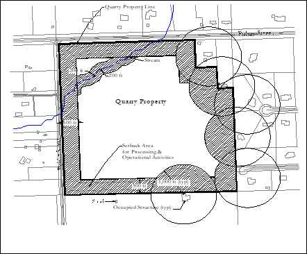
The minimum required setbacks for mine and quarry operations, which were not in existence and active and have not been approved pursuant to these regulations, shall not be less than those reported in the table below. Expanded areas of an existing mine or quarry shall also be subject to all the setbacks set forth below.
|
|
From Property Lines |
From Adjacent Occupied Residential
Structures * |
From water courses or bodies |
|
Area of extraction or removal of mined
or quarried material |
750’ |
1,000’ |
100’ |
|
Area of crushing, processing,
stockpiling, selling or other operational activities |
500’ |
1,000’ |
200’ |
|
*
Setbacks shall be from structures
existing at the time of the original permit approval pursuant to these
regulations. Setbacks for subsequent permits shall be set from the structures
existing at the time of the original permit approval providing that the mine
or quarry has not been abandon as defined in Section 5.B. of these
regulations. |
|||
Figure 14 – Illustration of Setback Minimums for Extraction and Removal Areas
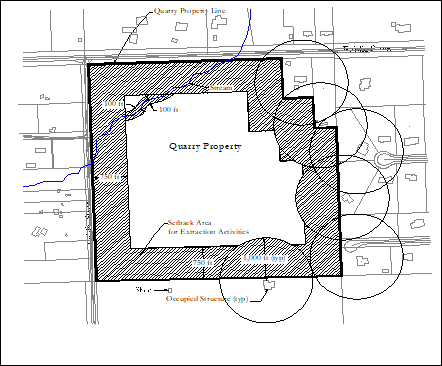
Figure 15 – Illustration of Setback Minimums for Processing and Operational Areas
(9) Mine and Quarry Special Use Permit Approval.
The approval of a quarry or mine special use permit shall require the approval of the Quarry Operations Plan, the Screening & Buffering Plan, and the Reclamation Plan by the Governing Body. Recognizing that certain uses may be desirable when located in the community, but that these uses may be incompatible with other uses permitted in a district, mine and quarry special use permits, when found to be in the interest of the public health, safety, morals and general welfare of the community may be permitted. The conditions, restrictions, methods, and assurances stipulated in these plans shall become part of the special use permit and be enforced by the City throughout the life of the permit. The official permit documentation shall consist of an ordinance granting the use of the subject property for mining or quarrying.
The ordinance shall include language relating to the following:
(a) The adoption of the approved Operations Plan, Screening & Buffering Plan, and Reclamation Plan.
(b) The reclamation bond, letter of credit, or other appropriate assurance amount. This amount shall be determined based on the engineer’s estimate of the cost of full reclamation as required in the Reclamation Plan. The assurance amount shall not be less than the amount required to fully reclaim any areas allowed by the Quarry Operations Plan to remain un-reclaimed or partly reclaimed.
Regardless of the engineer’s estimate, assurance amounts shall not be less than as stipulated below:
|
For
Dredging or sand pits: |
$1,000/Acre of operation |
|
For
Underground Mines: |
$500/Acre of mining operation. |
|
For
Open Pit Quarries: |
$5,000/Acre of open quarry |
Assurance amounts shall be reduced by the amount required by and held with the State.
(c) Any maintenance bonds required for the upkeep of public roadways.
(d) Any inspection and enforcement reimbursement required.
(e) The Permit length.
(f) Required park or infrastructure fees beyond those that would be required by the laws and ordinances of the City.
(10) Notification of Leasehold/Ownership Change.
The Mine or Quarry Operator shall, within five (5) days of any change in leasehold/ownership, notify City Planning Staff, who shall meet with the new operators and obtain a written statement that they will abide by the regulations and terms of the original permit. If no such written agreement is obtained, the permit shall be revoked and the mine or quarry operation stopped until such time as a new permit has been approved.
J. Telecommunications: (Section added 2004/Ord. 2060)
The general purpose of this section is to regulate the placement, construction and modification of telecommunications towers, support structures, and antennae, while at the same time not unreasonably interfering with the development of the competitive wireless telecommunications marketplace. Specifically, this section is intended to:
o Minimize adverse visual impacts of communications antennae and support structure through careful site design, siding, landscape screening and innovative camouflaging techniques;
o Maximize the use of existing and new support structures so as to minimize the need to construct new or additional facilities;
o Ensure that any new telecommunications tower or structure is compatible with the neighborhood or surrounding community to the greatest extent possible;
o Ensure that regulation of telecommunications towers and structures does not have the effect of prohibiting the provision of personal wireless services, and does not unreasonably discriminate among functionally equivalent providers of such service.
(1) Special Use Permit Required.
All proposals to install, build or modify an antenna or support structure not permitted by Paragraph 2 below, shall require the approval of Special Use Permit following a duly advertised public hearing by the Planning Commission, subject to the forthcoming limitations. All Special Use Permit applications shall include a landscaping plan and site plan as stipulated in Articles 8 and 11 of these regulations. In addition, the site plan shall include the location of and distance to off-site residential structures, required setbacks, required buffer and landscape areas, required lighting if any, hydrologic features, and the coordinates and height AGL of the existing or proposed tower.
(a) Applications.
(i) Applications of Special Use Permits shall be filed and processed subject to the requirements of and in the manner and time frame as established in this Article.
(b) Additional Minimum Requirements.
(i) No Special Use Permit shall be issued unless the applicant has clearly demonstrated that placement of an antenna or support structure pursuant to the City’s Permitted Uses requirements of this Article is not technologically or economically feasible. The Planning Commission may consider current or emerging industry standards and practices, among other information, in determining feasibility.
(c) Basis of Approval.
In addition to the determinations or limitations specified by this Article for the consideration of Special Use Permits, the Planning Commission shall also base its decision upon the existence of the following conditions:
(i) Applications for a new tower structure shall be considered only after a letter, certified by a Radio Frequency Engineer, clearly demonstrates that the planned telecommunication equipment cannot be accommodated on an existing structure, building, or approved transmission tower within the necessary geographic area for the applicant’s tower and clearly demonstrates one or more of the following conditions:
1). Planned telecommunications equipment would exceed the height or structural capacity of an existing or approved transmission tower, and the transmission tower cannot be reinforced to accommodate planned telecommunication equipment at a reasonable cost;
2). Planned telecommunications equipment will cause radio frequency interference with other existing or planned telecommunications equipment for that transmission tower and the interference cannot be prevented at a reasonable cost;
3). Existing or approved towers do not have space on which the planned telecommunications equipment can be placed so it can function effectively and at least in parity with other similar telecommunications equipment in place or approved by the City and or the appropriate county;
4). Retrofitting or redesigning the applicant’s tower network is not technologically or economically feasible;
5). Addition of planned equipment to an existing or approved transmission tower would result in NIER levels in excess or those permitted under Subsection e; or
6). Other reasons that make it impractical to place the telecommunications equipment planned by the applicant on an existing and approved transmission tower.
(ii) No application for a new tower structure shall be considered unless the applicant is unable to lease or otherwise secure space on an existing or planned telecommunication tower. Once the City finds that the telecommunications equipment proposed by the applicant cannot be accommodated on an existing or approved tower, each tower so found is presumed unable to accommodate similar equipment that may be proposed in the future, unless evidence is introduced to demonstrate otherwise.
(iii) The design of the tower or structure, including the antennae, shelter and ground layout should reduce visual degradation and otherwise comply with the provisions and intent of this section. New towers shall be of a monopole design.
(iv) That the applicant has not previously failed to take advantage of reasonably available shared use opportunities or procedures provided by this Article or otherwise.
(v) The City may require, at the expense of the petitioner, any additional studies or the hiring of an external consultant to review exhibits and/or other requirements in accordance with this section.
If any one, but not more than one, of the first four conditions is not satisfied, approval may be granted only upon a determination of unique circumstances otherwise necessitating approval to satisfy the purposes of this section.
(d) Additional Height Limitations.
(i) No tower shall be approved at a height exceeding 150-feet AGL (Above Ground Level) unless the applicant clearly demonstrates that such height is required for the proper function of the applicant’s system or that of a public safety communications system of a governmental entity sharing the tower. Such showing must also be supported by the opinion of a telecommunications consultant hired by the city at the expense of the applicant. The opinion of the consultant shall include a statement that no available alternatives exist to exceeding the height limit or the reason why such alternatives are not viable.
(e) Non-Ionizing Electromagnetic Radiation (NIER) Standards.
(i) All transmission facilities shall conform to the relevant sections of the “American National Safety Levels with respect to Human Exposure to Radio Frequency Electromagnetic Fields, 3 KHz to 300 GHz”. This standard as identified by as ANSI- C95.1-1999 and is published by the American National Standards Institute, a copy of which is incorporated herein by reference and will be made available upon request to the Planning Department.
(f) Term of Special Use Permit.
(i) An initial Special Use Permit for a communication tower shall not be approved for a duration longer than 5-years. Subsequent renewal periods shall not exceed 10-years. At the time of each renewal the applicant shall demonstrate to the satisfaction of the City that a good-faith effort has been made to cooperate with other service providers to establish co-location at the site. Good-faith effort may include, but is not limited to, reasonable and timely response to co-location inquiries from other service providers and sharing of technical information to evaluate the feasibility of establishing co-location. Failure to demonstrate that good-faith efforts have been made may result in the denial of the request for a renewal.
(2) Permitted Uses.
(a) The placement of Antenna and Towers are permitted upon the issuance of a Building Permit, without the issuance of a Special Use Permit, only under the following circumstances:
(i) The attachment of additional antennae or shelters, or replacement thereof, to any tower existing on the effective date of this Article or subsequently approved in accordance with these regulations, including the enlargement of the existing tower compound area as long as all other requirements of this section and the underlying zoning district are met.
(ii) The mounting of antennae on any existing building or structure, such as a water tower, provided that the antenna does not extend higher than 10-feet above the structure.
(iii) The mounting of antennae on or within any existing high-voltage electric transmission tower, but not exceeding the height of such tower by more than 10-feet.
(iv) Reserved.
(v) The one-time replacement of any tower existing on the effective date of this Article or subsequently approved in accordance with these regulations so long as the purpose of the replacement is to accommodate shared use of the site or to eliminate a safety hazard. The new tower shall be of the same type as the original except that a guyed or self-supporting (lattice) tower may be replaced by a monopole. If the guyed or lattice tower to be replaced is 180 feet or less in height, it shall only be replaced with a monopole, and the height of the new tower may exceed that of the original by not more than 20-feet.
(b) Application and Appeal Procedures.
(i) Applications for Building Permits shall be made in the same manner as those for any other Building Permit within the City.
(3) General Requirements.
The requirements set forth in this section shall be applicable to all towers, antennae and other support structures installed, built or modified after the effective date of this Article to the full extent permitted by law.
(a) Principal or Incidental Use.
(i) Antennae and support structures may be either a principal use in all zoning districts except “C-1” Business Central or “R-H” Residential Historic districts or an incidental use to institutional or non-residential uses, subject to any applicable district requirement relating to yard or setback.
(b) Regulatory Compliance.
(i) All antennae and support structures shall meet or exceed current standards and regulations of the Federal Aviation Administration (FAA), Federal Communications Commission (FCC) and any other state or federal agency with the authority to regulate communications antennae and support structures. No approval for any placement, construction or modification of any antenna or structure permitted by this section shall be granted for any applicant having an uncured violation of any other governmental regulatory requirement related to such antenna or structures within the City.
(c) Lighting.
(i) Antennae, equipment cabinets, shelters, and support structures shall not be lighted unless required by the FAA or other state or federal agency with authority to regulate.
(d) Advertising.
(i) Except for a disguised antenna support structure in the form of an otherwise lawfully permitted pylon sign, the placement of advertising on structures regulated by this section is prohibited.
(e) Design.
(i) Subject to the requirements of the FAA or any applicable state or federal agency, towers shall be painted a neutral color consistent with the natural or built environment of the site.
(ii) Equipment shelters or cabinets shall have an exterior finish compatible with the natural or built environment of the site and shall also comply with any design guidelines as may be applicable to the particular zoning district in which the facility is located.
(iii) Antennae attached to a building or disguised antenna support structure shall be of a color identical to or closely compatible with the surface to which they are mounted.
(iv) All towers and support facilities shall be surrounded by a minimum 6 foot high decorative fence consisting of elements of brick, stone or comparable masonry materials. Chain link or similar wire fencing shall not be allowed for the exterior screening fences. In lieu of the required fence and landscaping, an alternative means of screening may be approved by the Planning Commission, upon demonstration by the applicant that an equivalent degree of visual screening will be achieved.
(v) All towers, disguised support structures, and related structures, fences and walls shall be separated from the property line of any adjacent property at least a distance equal to the height of the tower except where adjacent to property zoned for commercial or industrial uses, in which case the tower and related facilities shall be separated from adjacent property lines at least a distance equal to one-half of the height of the tower or structure. Decreased setbacks may be approved at the discretion of the Planning Commission in the case of a Special Use Permit.
(vi) Vehicle or outdoor storage on any tower site is prohibited, unless otherwise permitted by the zoning.
(vii) On-site parking for periodic maintenance and service shall be provided at all antenna or tower locations consistent with the underlying zoning district.
(f) Shared Use.
(i) Tower Inventories. Prior to the issuance of any permit to install, build or modify any tower, the tower owner shall furnish the Zoning Administrator an inventory of all of that owner’s towers in or within one and one-half miles of the City limits. The inventory shall include the tower’s reference name or number, the street location, latitude and longitude, structure type, height, type and mounting height of existing antennas and an assessment of available ground space for the placement of additional equipment shelters.
(ii) Shared Use Required - New Towers. Any new tower approved at a height of 60 feet AGL or higher shall be designed and constructed to accommodate at least one additional user.
(4) Obsolete Non-Complying Tower Structures.
Any upper portion of a tower which is not occupied by active antennae for a period of twelve months, and any entire tower which is not so occupied for a period of six months, shall be removed at the owner’s expense. Any applicant for a new tower or disguised structure not built as disguised part of another existing or permitted structure shall place a bond or other security with the City prior to any final approval for the purpose of removing any tower or disguised structure as required herein and to compensate the City for performing proper maintenance of such towers or disguised structures to ensure such structures do not become unsafe or otherwise fail to be maintained in compliance with this Article. The bond or security shall be in the form approved by the City, and in the amount of $15,000, or such other amount as is determined by the City to satisfy the requirements hereof with regard to the specific tower or structure to which it would apply. Removal of upper portions of a tower manufactured as a single unit shall not be required. Failure to comply with this provision shall constitute a nuisance that may be remedied by the City at the tower owner’s expense.
K. Accessory Structures shall be permitted within established front yards subject to the following conditions: (Section Added 2007/Ord. 2165)
(1) Property must be no less than three (3) acres. Adjoining lots or tracts under common ownership shall not be included in this figure.
(2) Accessory structure must not infringe upon front or side yard setbacks.
(3) Accessory structure must be constructed of the same or similar materials and have an appearance and landscaping consistent with the principal structure on the property.
(4) The request must arise from environmental or topographical conditions unique to the applicant’s property that would make siting the accessory building elsewhere unfavorable.
At the time of application submittal, the applicant shall submit a letter to the Planning commission stating the reasons for their request.
L. Pole Signs allowed by special use permit pursuant to this Article and restricted to properties (1) zoned “M-1” Light Industrial, “M-2” Heavy Industrial,”C-2” General Business, or “O-I” Office Institutional, and (2) located within the “K-10 Pole Sign Overlay District”, which is defined as that area of land which extends from the center of the K-10 Highway median 1,320 feet in each direction, for a total width of 2,640 feet the entire length of K-10 Highway within the city limits.
1. Statement of Purpose: Pole signs allowed under a Special Use Permitting process are offered as a means to attract retail traffic to De Soto business when other types of legal signs are not adequate and when it can be demonstrated that a pole sign is necessary for a business due to topography, visibility, or other factors.
A Special Use Permit may only be approved when it can be determined that the benefit to the City from such pole sign will:
• sufficiently outweigh possible negative impacts upon surrounding property values,
• have a minimum impact upon traffic safety,
• outweigh the negative appearance of the De Soto community at large resulting from a proliferation of such signs.
The applicant shall provide sufficient information so the below considerations may be properly evaluated concerning a proposed pole sign.
2. Specific Considerations for Pole Sign Permits. The following items shall serve as general, non-binding standards in conjunction with a Special Use Permit application for a pole sign. Other issues may also need to be examined depending upon the specific sign proposed.
a. Height shall be no more than 60 feet from grade, including all logos, symbols, extensions, or extrusions.
b. Sign face area shall be no more than 400 square feet. This shall include all sign faces on one side of a single, double or V-faced sign;
c. Each parcel or lot is limited to having one pole sign. In the event that a single business venture occupies more than one parcel or lot, that business is limited to one pole sign.
d. Each lot is limited to having one pole sign and the lot must contain at least one principal use. This pole sign allowance is in addition to all other signs allowed on the lot.
e. Setbacks & Location:
i. Pole signs should generally observe a minimum setback of 10 feet from front and rear property lines.
ii. No sign shall be allowed within a public utility, or drainage easement or, public right-of-way;
iii. The side yard setback for a pole sign generally should equal the height of the sign.
f. Color and type of materials: Loud, fluorescent or unusual colors or flashy materials should be avoided.
g. Illumination:
i. Type of illumination is limited to LED and must conform to the standards set forth on the ISA Electronic Message Display Brightness Guide published by the International Signage Assn.
ii. Signs shall automatically dim at night or during other low-light situations.
iii. Illuminated signs must be internally lit.
3. Master Signage Plan. The pole sign shall be designed to meet the provisions of the master signage plan for the site. The Master Signage Plan must be submitted with the site plan, if applicable.
M. Electronic Variable Message Board Signs on property zoned “M-1” Light Industrial, “M-2” Heavy Industrial, “C-1” Business Central, and “C-2” General Business, OI Office Institutional. Also allowed for the Churches, Schools and Civic Uses
Definition of Electronic Variable Message Board (EVMB or a Digital Sign): A sign capable of displaying words, symbols, figures or images that can be electronically changed by remote or automatic means.
Statement of Purpose: EVMBs allowed under a Special Use Permitting process are offered as a means to attract retail traffic to De Soto business when other types of legal signs are not adequate and when it can be demonstrated that an EVMB is necessary for a business due to topography, visibility, or other factors.
A Special Use Permit may only be approved when it can be determined that the benefit to the City from such EVMB will:
• sufficiently outweigh possible negative impacts upon surrounding property values,
• have a minimum impact upon traffic safety,
• outweigh the negative appearance a proliferation of such signs may provide of the De Soto community at large.
The applicant shall provide sufficient information so the following issues may be properly evaluated concerning a proposed electronic variable message board.
1. Location Restrictions:
a. Signs shall not be placed closer than 200 feet from a single or two-family residence.
2. Sign Types Allowed:
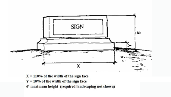
a. Ground Sign: Any sign placed upon, or supported by, the ground independent of the principal structure on the property, where the bottom edge of the sign is less than six feet above the ground, and the base is no less than 50 percent of the width of the face of the sign, presenting a monolithic structure.
b. Monument Sign: Any sign whose base is greater in width than the face of the sign, and whose height is no greater than 6 feet.
3. Number Restrictions:
a. One EVMB sign on each building, lot or parcel.
b. A maximum of one EVMB sign is permitted per property, business or business center occupied by multiple businesses, uses or buildings.
4. Use Restrictions:
a. May be permitted by Special Use Permit for commercial or retail establishments in the C-1, C-2, M-1 or M-2 OI-Office Institutional zoning districts.
b. May be permitted by Special Use Permit for civic organizations, schools and churches.
5. Size:
a. The area of the electronic display cannot be more than 75 percent of the total area of the sign face.
b. The size of the EVMB sign shall count toward the allowable size of the sign upon which they are mounted.
6. Illumination Levels
Limitations
a. Electronic and digital signs must use automatic level controls to reduce light levels at night and under cloudy and other darkened conditions. All electronic and digital signs must have installed ambient light monitors and must at all times allow such monitors to automatically adjust the brightness level of the electronic sign based on ambient light conditions. Maximum brightness levels for electronic and digital signs may not exceed 5000 nits when measured from the signs face at its maximum brightness, during daylight hours, and 500 nits when measured from the signs face at its maximum brightness between sunset and sunrise.
b. The digital sign may not display light of such intensity or brilliance to cause glare or otherwise impair the vision of the driver or result in a nuisance to the driver. The EVMB shall not interfere with any driver’s operation of a motor vehicle or the safety of the public or be located where it would do so, as determined by the City Engineer.
Auto dimming
An EVMB sign must be equipped with both a dimmer control and photocell, which automatically adjusts the display’s intensity according to natural ambient light conditions.
Other
Lighting of EVMB signs shall be shielded to prevent glare.
7. Timing:
Display Duration: Any image or message or portion thereof displayed on a sign shall have a minimum display time duration of 8 (eight) seconds and may be a static or scrolling display.
Transitioning
a. Message transition shall occur simultaneously over the entire face of the electronic message sign.
b. Transition time shall be no longer than two seconds and black space is not permitted between message changes.
c. The image, symbol or combination change shall be accomplished within 2 seconds and occur simultaneously. Once changed the symbol or image shall remain static until the next change.
d. Messages shall change using a dissolve or fade transition, or with the use of other subtle transitions that do not scroll, flash, or otherwise
Hours: For all locations within 500 feet of a single family or two-family residential district, illumination shall be turned off between the hours of 10:00 pm and 6:00 am.
8. Visual and Sound Effects
Animation: Animation is allowed on electronic changeable message signs provided it does not include flashing, rapidly changing or blinking illumination, rotating beams or illumination resembling emergency lights, which are all prohibited.
Audio: Electronic signs shall not contain or utilize audio speakers or any form of pyrotechnics.
Malfunction Provisions:
a. The sign shall be programmed to default to a blank screen or freeze the display in a static position in the event of a malfunction.
b. The sign owner shall provide on the sign permit, contact information for a person who is available to be contacted at any time and who is able to turn off the electronic changeable message sign promptly after a malfunction occurs.
9. Message Content Restrictions:
a. All graphics and lettering displayed on electronic signs shall meet public decency standards.
b. The EVMB sign shall not be configured to resemble a warning or danger signal or cause a driver to mistake the digital sign for a warning or danger signal.
c. No part of the EVMB shall mimic the appearance or operation of any traffic control device, signal or notice.
10. Other Conditions
a. All illuminated signs, including EVMB shall comply with the National Electric Code and other codes as applicable.
b. Portable electronic signs are prohibited.
c. EVMB within sight line of any traffic control or safety device shall be subject to approval by the City Engineer.
d. Directional signs, contractor’s remodeling signs, sandwich boards, and real estate signs, shall not be EVMB.
(Ord. 2348; Ord. 2349; Ord. 2610)
N. Manufactured Home Dwellings on property zoned “R-A” Residential Agricultural, “R-H” Residential Historic, “R-0” Residential Suburban, “R-1” Residential Low Density, and “R-1A” Residential Moderate Density.
Statement of Purpose: The purpose of this section is to allow for the replacement of an older mobile home or manufactured home for the purposes of upgrading to a newer unit, or replacing a damaged or destroyed unit. A Special Use Permit may only be granted for a manufactured home dwelling that is replacing a specific mobile home or manufactured home that existed on a lot or tract within the year preceding the application for the Special Use Permit.
A Special Use Permit may only be approved when it can be determined that the benefit to the City from the replacement of an existing [or one that was removed within the year preceding the application for the Special Use Permit] manufactured or mobile home will:
• sufficiently outweigh possible negative impacts upon surrounding property rights and values,
• provide a significant upgrade to the form, function, appearance, and compatibility from the existing or previously existing dwelling unit,
• outweigh any negative aspects of the proliferation or continuance of manufactured home dwellings to the De Soto community at large.
The applicant shall provide sufficient information so the following issues may be properly evaluated concerning a proposed replacement of an existing [or one that was removed within the year preceding the application for the Special Use Permit] dwelling.
1. Applicability: A Special Use Permit for the replacement of a mobile home or manufactured home dwelling shall only be considered in the following instances:
a. In the event of un-intentional damage to or destruction of an existing mobile or manufactured home, as defined in Article 9, Section 4E of these regulations.
b. To replace a mobile home or manufactured home currently existing outside of a mobile home park on an individual lot or tract within an R-A, R-H, R-0, R-1, or R-1A zoning district, or meets the requirements set forth in this subsection (b) but was removed from the individual lot or tract within the year preceding the application for the Special Use Permit.
2. Location Restrictions:
a. All applicable yard set-back requirements must be met.
b. No manufactured home shall be placed within an easement.
c. The replacement manufactured home shall be situated on the property as to negate any negative impacts to surrounding properties. A replacement manufactured home should be placed in the same location on the property as the original, providing that adjustments may be made for larger structures or to meet yard requirements.
d. Only one manufactured home dwelling may be placed on a lot or tract.
3. General Standards:
a. Skirts. Each manufactured home shall be equipped with skirts on all sides, such skirts to be of a material harmonious to the mobile home structure.
b. Parking. Off-street parking shall be provided within 60 feet of the manufactured home and shall be maintained at a minimum ratio of two car spaces for each manufactured home.
c. Utilities. The water supply shall be connected to the municipal water system and all plumbing shall be constructed and maintained in accordance with the city’s plumbing code. All liquid waste shall be disposed of through the municipal sanitary sewer system. All plumbing shall comply with state and local plumbing laws and regulations. Each manufactured home shall be provided with at least a four inch sewer connection. The sewer connections shall be provided with suitable fittings so that a water tight connection can be made between the mobile home drain and the sewer connection.
d. Refuse Disposal. All solid waste shall be disposed of by accumulation in containers distributed by the city’s contractor and removal at regular intervals by the city’s contractor.
e. Electricity. All electrical installations shall comply with the electrical code of the city. Electrical outlets shall be weather-proof. An electrical outlet supplying at least 115 volts shall be provided with a minimum of 60 ampere individual service.
f. Fuel. Natural and liquefied petroleum gas for heating and cooking purposes may be used at individual manufactured homes; provided, however, that the installation is connected by copper or other suitable metallic tubing and complies with the fire prevention code of the city.
(Ord. 2379)
O. Wedding and Reception Halls. Wedding or Banquet halls allowed by special use permit pursuant to this Article are restricted to properties that are not within the C-1, C-2 and O-I zoning district. The special use permit for a Wedding or Reception Hall shall be regulated in accordance with this section.
1. General Requirements
a. Events will consist of renter or property owner conducting weddings, receptions, parties, corporate retreats and educational activities.
b. Minimum size of tract is set at 5 acres for this activity.
c. Food services and catering may be provided by others. Outdoor grilling is allowed.
d. Trash must be collected and disposed off-site.
e. Portable bathrooms are not allowed as permanent toilet facilities.
f. Hours of operation are limited to 8am-12am, 7 days a week.
g. The applicant will ensure that the activities continually meet the requirements of the international building and fire code adopted by De Soto, and other applicable codes during the term of the special use permit. The City Building Official must approve all code issues.
h. All employee and guest parking shall be off-street and out of the public right-of-way, and on the subject property. Guest parking spaces provided will be at 1 space per 2.5 guests. Total parking shall be established by the maximum occupancy as determined by the City Building Official. Parking areas must, at a minimum, be on a hard base with compacted gravel.
i. Vegetative buffers or other protection must be provided by the Owner per De Soto City code, Appendix C - Article 8.
j. Outdoor lighting shall be limited to the outdoor event areas and parking areas. There shall be no light spillage or light glare off-site.
k. Should dust from the parking lot or drives be visible upon adjacent property, the owner shall take measures to control the dust.
l. Any noise must be kept to a minimum and must comply with Article 8 of Chapter 8 of the De Soto City Code.
m. The term of the special use permit shall be a maximum of 20 years, commencing on the effective date of the special use permit ordinance adopted by the governing body.
2. Permits and Submittals
a. A Site plan, as defined in Article 11 of the De Soto Zoning Regulations, will be submitted for review by the Planning Commission.
P. Indoor Display and Sale of Motor Vehicles and Parts. The indoor display and retail sale of Motor Vehicles, and Motor Vehicle Parts, may be permitted in the “C-1” Business – Central District upon approval of a special use permit. For purposes of this section, Motor Vehicles shall be limited to “passenger cars”, defined as a road motor vehicle, other than a motorcycle, intended for the carriage of passengers and designed to seat no more than ten persons (including the driver).
1. General Requirements.
a. All Motor Vehicles and/or parts located on the permitted property must be stored, repaired, parked, displayed and/or offered for sale wholly inside the permitted permanent structure.
b. A show room for display and sales inside the permanent structure must be established and business hours posted.
c. Any signage proposed to be used must comply with city sign regulations and conform to any additional conditions imposed as part of the special use permit.
d. Fumes or exhaust from operation of the business must be safely vented in accordance with industry standards, and any applicable city, state, and/or federal regulations.
e. At least eighty percent of the Motor Vehicles displayed and/or offered for sale (at any given time) must meet the definition of being an “antique” under Kansas law, currently more than 35 years old as set forth in K.S.A. 8-166(a).
f. Noise from equipment and/or vehicles must comply with the city’s noise regulations set forth in Article 6 of Chapter 8 of the City Code.
g. Any vibration from equipment and/or vehicles must be confined to the permitted permanent structure.
2. Submittals.
a. A Site plan, as defined in Article 11 of the De Soto Zoning Regulations, will be submitted for review by the Planning Commission, and should include an architectural development plan for the interior of the permanent structure.
b. The city engineer will determine if an evaluation from a licensed structural engineer needs to be submitted with the special use permit application, addressing capability of the permanent structure to adequately support the weight of vehicles and parts proposed to be located within the structure.
Q. Utility-Scale Solar Facilities. Utility Scale Solar Facility (hereafter “USSF”) special use permits, when found to be in the interest of the public health, safety, morals, and general welfare of the community may be permitted. In addition to the requirements for other special use permits, USSF’s will obtain a special use permit in accordance with this section. The approval of such special use permit application by the city is a purely discretionary act that will be decided based upon the facts and circumstances discovered in the review of each application.
1. Application for a special use permit for a USSF in De Soto can only be accepted for an area within 119th Street (Northern Limits), 143rd Street (Southern Limits) Evening Star Road (Western Limits) and String Town Road (Eastern Limits). Formerly known as the Sunflower Army Ammunition Plant. (SAAP).
2. DEFINITIONS:
Battery Energy Storage Facility (BESF) - One or more battery cells for storing electrical energy and includes battery management system regulators equipment and secondary containment.
Battery Management System (BMS) - An electronic regulator that manages a Battery Energy Storage System by monitoring individual battery module voltages and temperatures, container temperature and humidity, off-gassing of combustible gas, fire, ground fault and DC surge, and door access and capable of shutting down the system before operating outside safe parameters.
Environmental Impact Assessment - an evaluation of the environmental consequences of a plan, policy, program, or projects.
Photovoltaic Solar Panel - Materials and devices, including photovoltaic panels, that absorb sunlight and convert it directly into electricity.
Utility Scale Solar Facility (USSF) - A Solar Facility located on a Solar Facility Area of more than 1,000 acres. A facility of this size is typically equivalent to a rated capacity of one megawatt (MW) alternating current or greater. Such facilities are used to provide electricity to a utility provider.
Project Area - An area of land in acres used for converting sunlight into electricity including the necessary equipment for generating electricity, which shall include Solar Panel Photovoltaics, inverters; substation parking lots, support structures (which may include buildings); electrical substations and Battery Energy Storage Facilities.
Project Extent – The entire area including property and setback lines, lease lines, streets, easements, landscaping, wildlife corridors, right-of-way corridors and utility easements, and includes the Project Area. Areas that don’t count towards the project extent are remaining sites that are not ready for development due to Army Corps of Engineers’ clean-up efforts.
Wildlife Corridor - a strip of natural habitat connecting populations of wildlife that serve as a traveling avenue for wildlife species and provide sources of food and cover.
Remnant grassland and woodland - is an area containing native flora and fauna that has not been significantly disturbed by activities such as development, logging, transportation, or pollution.
Solar Facility Decommissioning and Reclamation Plan - A plan to disconnect, remove, and properly dispose of equipment, facilities, or devices of a Solar Facility and reclaim the site.
3. Required Utility Scale Solar Facility Application Special Use Permit Submittal Information.
a. Preliminary Concept Plan: A Preliminary Concept Plan will be submitted to the De Soto Planning Director. A pre-application meeting is required. The Preliminary concept plan must be submitted 30 days prior the pre-application meeting. The Preliminary Concept Plan will consist of aerial imagery of the Project Area (actual area with solar panels coverage, battery storage facilities, substations etc.) and the Project Extent (Total project area with setbacks, wildlife corridors, right-of-way and easements etc.), and the general location and arrangement of screening, fencing, tree preservation, structures, battery storage, driveways and entrances, wildlife corridors, floodplain, and electric and overhead utility lines to include the route of private electric power transmission lines from the USSF to the points of connection to the grid. Elevations of structures shall be included with the Concept Plan.
b. Supplemental Narrative to Preliminary Concept Plan: A narrative giving a general overview of the USSF, which includes:
i. The applicant, owner, and the operator of the proposed USSF.
ii. The current uses and physical characteristics of not only the Project Area but also the surrounding area.
iii. The intended energy provider to interconnect to the US Solar Facility.
iv. A development agreement (including items the City of De Soto needs for determining Franchise Fees or equivalent compensation, completed preliminary and final development plan and any tax incentive requests. If a “back of the meter” approach is utilized, then a payment in lieu of franchise fees to the City of De Soto will need to be included in the Development agreement.
v. Approximate Rated Capacity of the USSF project.
vi. Type and location of interconnection to electrical grid and details of coordination and pre-approval with the local energy provider.
vii. A copy of the interconnection agreement with the local energy provider or a written explanation outlining why an interconnection agreement is not necessary.
viii. Approximate number of solar panels and representative types.
ix. The Project Area and Project Extent expressed in acres.
x. An inventory with descriptions of all proposed structures and uses including Battery Energy Storage Facilities, inverters, substations, and all structures over 35 feet in height.
xi. An inventory of all Solar Facilities within two (2) miles of the Project Extent.
xii. A visual impact analysis demonstrating project siting and, if necessary, proposed mitigation to reduce impacts on the visual character of the surrounding area.
c. Final Development Plan: After the Preliminary Concept Plan meeting, a formal Development Plan will be submitted to the De Soto Planning Director. The Application review time for Special Use Permits for USSFs may take up to 75 days from the time of submittal. This is based upon the potential size and complexity of the application as determined by factors that include but are not limited to the number of third-party reviews to be coordinated and completed and the Project Area of the USSF. The Special Use permit application will include the following:
i. A visual impact analysis demonstrating project siting and, if necessary, proposed mitigation to reduce impacts on the visual character of the surrounding area.
ii. The Project Area, Project Extent and Solar Photovoltaic Panel Coverage area, Battery Energy Storage Facilities and Sub-Stations expressed in acres.
iii. The Project Extent, property and setback lines, lease lines, streets, easements, landscaping, wildlife corridors, right-of-way and utility easements, and to include the Project Area.
iv. Location of driveways, parking and entrances onto streets and accompanying site distance reports for such entrances.
v. Locations and dimensions of all existing and proposed structures, including PV panels, charge regulators, inverters, substations, Battery Energy Storage Facilities, connections to the grid, fencing, and dwellings and associated structures, including the location of all dwellings within 300 feet of the Project Extent.
vi. Elevations of structures depicting the style, size, and exterior construction materials in sufficient detail to exhibit the relative compatibility of the proposed development with the character of the neighborhood.
vii. A grading plan indicating existing and proposed contours at no greater than two-foot (2-foot) contours.
viii. A stormwater management plan in accordance with applicable standards/regulations. The stormwater management plan will include, but not be limited to, the following sections:
a) Water quantity analyses and requirements.
b) Stream buffer analyses and requirements.
c) Post-Construction Stormwater Quality Treatment Regulation requirements.
d) Federal Emergency Management Agency floodplain regulations/requirements.
ix. A landscaping plan in sufficient detail including specifications, installation, proposed ground cover, including seed mixes, screening materials, and herbicides used.
x. The design and specifications for additional vegetative screening for nearby residences.
xi. Locations of wildlife corridors and details regarding fencing, if any, that accommodate wildlife movement.
xii. Locations of remnant grasslands and woodlands (which are areas that have not been previously plowed or graded).
xiii. Proposed clearing or grading of natural vegetation including Stands of Mature Trees and remnant grasslands and woodlands, which may be a separate plan.
xiv. Decommissioning and Reclamation Plan: A plan for decommissioning and reclamation of the site shall be submitted as part of the application. The plan shall be certified by a professional engineer licensed in the state of Kansas who has expertise in the removal of USSFs (e.g., educational knowledge or practical experience).
xv. Lifespan: The anticipated life of the project.
xvi. Implementation: The manner in which the project will be de-commissioned, and the site reclaimed to include but not limited to plans for stabilizing the soils, regrading, reseeding, and replanting, and disposal and recycling the USSF materials, including but not limited to PV panels, inverters and batteries.
xvii. Estimated Costs of Decommissioning and Reclamation: A detailed cost estimate for decommissioning and reclamation of the USSF in accordance with the Decommissioning and Reclamation Plan.
xviii. Traffic Plan: A preliminary traffic plan describing estimated travel routes and trip volumes during the construction and decommissioning processes. Public road improvement, repair and maintenance during installation and operations will be required and will be coordinated with the City Engineer. Damage to public roads will be repaired at the solar operator’s expense.
xix. Construction Management Plan: A construction management plan to include an estimated construction schedule and hours of operation.
xx. Environmental Impact Assessment: An environmental impact assessment to include an assessment of viewshed impacts, including impacts on national or state forests and grasslands, national or state parks, county or city parks, wildlife management areas, conservation easements, recreational areas, or any known historic or cultural resources including the project area and within one (1) mile of the Project Extent.
xxi. Airport Studies: For the purpose of determining impacts on area airports, a glare impact study and/or an airspace study in accordance with, and if required by, Federal Aviation Administration (FAA) requirements.
xxii. Fire and Life Safety Program that includes coordination and responder training with the NW Consolidated Fire District and includes Hazardous Materials Risks. All designs will conform to the latest edition of all applicable codes and standards. Currently this includes the 2018 International Fire and Building Codes.
xxiii. Final Development Plan and Application Review Time: 75 Days
xxiv. Applicant shall provide a list and map identifying all non-available parcels that are within the proposed USSF project extent.
d. USSF Development and Performance Standards:
i. Permit Term of USSF: A Special Use permit for a USSF may be approved for a period not to exceed 40 years which shall commence upon the earlier of (A) completed construction of a USSF or (B) the second anniversary of the Special Use permit approval.
ii. The minimum Project Extent of a USSF will be more than one thousand 1,000 acres in size. It is anticipated that the project will begin development from the southern boundary (143rd Street) and move towards the north, not to exceed 119th Street.
iii. USSFs shall be located greater than five (5) miles from the Project Extent of the New Century AirCenter.
iv. Waiver: In the event that an applicant desires to deviate from the Development and Performance standard requirements, the applicant will submit written information to the De Soto Planning Director indicating the circumstances which are believed to necessitate the need for a deviation from the development and performance standards. The additional consideration may be granted only if the request is affirmed by the De Soto City Council to be reasonable to deviate from the adopted policy.
e. Project Area Setbacks: The setback of structures associated with the USSF from the Project Area or, if applicable, public streets whichever is nearest to such structures, will be a minimum of 100 feet, with the exception that substations and Battery Energy Storage Facilities will be set back a minimum of 200 feet.
f. Setbacks from Dwellings: To minimize adverse impacts upon nearby surrounding residential uses located outside of the Project Area, the minimum setback of structures and uses associated with the USSF, including fencing and PV panels, but not including landscaping and berming, will be not less than 300 feet from all dwellings that are located outside of the Project Area and existing at the time the USSF was approved by the De Soto City Council.
g. Height: The height requirements of structures associated with USSFs shall be as follows:
i. The maximum height of the lowest edge of the photovoltaic panels shall be 10 feet and the maximum height of the highest edge of the photovoltaic panels shall be 15 feet, as measured from the finished grade; and
ii. The maximum height of all other structures associated with the USSF shall be 35 feet as measured from the finished grade at the base of the structure to its highest point, including appurtenances with the exception of electrical power transmission lines, which are exempt from height requirements of these regulations.
h. Security Fencing: USSF equipment and structures may be enclosed by security fencing not more than 12 feet in height. The fencing material can be chain link.
i. Security fencing can be placed around sections of photovoltaic PV solar panels and other structures rather than around the Project Extent in its entirety in order to provide pathways between the sections for the purpose of allowing the movement of wildlife. The fencing should be constructed with materials and a design that promotes the surrounding character, woven wire fencing with wooden posts may be more in keeping with the character of a rural area than chain link fencing with metal posts.
ii. The use of permeable fencing, which is constructed to allow wildlife to pass through the fence, is encouraged. Woven wire fencing with larger holes than a traditional chain link fence is an example of fencing that accommodates wildlife.
i. Wildlife Corridors: Access corridors for wildlife to navigate through the USSF shall be provided and shown on the Concept Plan and Development Plan submitted to the City. Driveways within the Project Area may be considered a type of wildlife corridor.
j. Utility/Corridors: Road and Utility corridors (existing and future) will be identified and approved by the De Soto Planning Director to allow for transportation access and utility services to be extended through the site if necessary. The future land use plan and other roadway and utility studies will be used for reference.
k. Ground Cover and Vegetation Preservation: For the purpose of preventing erosion and managing runoff, disturbed land, to include land under and around the PV panels shall be seeded with a revegetation seed mix based on prairie grasses and forbs native to the Midwest United States. The intent of such seeding is to establish a short stature prairie with a diversity of grasses and wildflowers that bloom throughout the growing season. Such ground cover shall be continually maintained on the site for the duration of the Special Use permit. A list of seed mixes appropriate for Midwest USSFs are available at the Johnson County Extension Office. USSF shall be designed and developed to minimize grading and to protect and preserve Mature Trees, Stands of Mature Trees, tree-lines, streamways, ponds, and other natural features, and, in particular, remnant grasslands and woodlands (which are areas that have not been previously plowed or graded) to the greatest extent reasonable and practicable.
l. Screening: The purpose of screening is to help avoid potential detrimental impacts that may accompany the USSF. The required Project Extent Setbacks provide a measure of screening by providing increased distance or setbacks from exterior property lines to reduce impacts associated with the USSF.
i. USSF structures, including security fencing that is not ornamental, PV panels, equipment cabinets, substations, Battery Energy Storage Facilities, parking areas, and outdoor storage, if allowed, shall be screened when visible from any road, residential district, and any dwelling located outside of the Project Extent and existing at the time the USSF was approved by the De Soto City Council.
ii. Screening Methods: The applicant will use one or a combination of methods listed in this section, or other comparable methods deemed equivalent by the Planning Director, to satisfy the screening requirements. The method or methods proposed by the applicant will screen ground level views and activity. Such screening shall be located within the Buffer Zone and outside of security fencing and may also be required in other locations to screen specific uses or structures, such as substations and Battery Energy Storage Facilities. Screening shall not encroach upon the street right of way. The De Soto City Council may approve a plan to allow phased screening based on special or unique conditions of the use or site. The screening required by this section shall be shown on the required Landscaping Plan that is a part of the Development Plan.
iii. Existing vegetation, topography, buildings, open space, or other elements located on the site may be considered as part of the required screening.
iv. Landscaping intended for screening shall include a combination of evergreen trees that are 5-6 feet in height at time of planting and deciduous trees, which may include fruit trees, that are 5-6 feet in height at time of planting. Trees shall be placed on average at 25 feet or less on center. A plant schedule with specifications needs to be submitted by a licensed Landscape Architect.
v. Berms shall generally be constructed with a 3:1 side slope to rise ratio, 4-6 feet above the adjacent grade, with a 3-foot wide top (the wide top is necessary to have a flat area for plantings). The outside edges of the berm shall be sculpted such that there are vertical and horizontal undulations to give variations in appearance. All land berms shall be seeded with a revegetation seed mix based on prairie grasses and forbs native to the Midwest United States. A list of seed mixes appropriate for the area is available at the Johnson County, KS extension office
vi. Fencing intended for screening shall be at least seventy-five (75) percent visually solid as viewed on any line perpendicular to the fence from adjacent property or a public street. Such fencing may be used in combination with other screening methods but shall not be the primary method, which shall mean for the purposes of this subsection that fencing shall not be used to screen more than thirty (30) percent of the views required to be screened. A typical example is the use of a combination of wood privacy fencing and landscaping to screen structures such as substations. Depending on the location, such as abutting residential zoning, ornamental features may be required on the fence. Fencing material shall not include chain link fencing with slats.
vii. Additional Screening for residences: In addition to the above screening requirements, any residence at the time the USSF was approved by the De Soto City Council, that is located 300 feet or less from the Project Extent, shall receive additional vegetative screening from views of the USSF structures. Such vegetative screening shall be located within the Buffer Zone in an area extending at least 75 feet from either side of the dwelling (but shall not be required in any area outside of the Project Area). The vegetative screening shall be one-hundred (100) percent visually solid as viewed on a line from the dwelling and perpendicular to the Project Extent. The vegetative screening shall achieve a height of at least eight (8) feet or the height of the security fencing, whichever is greater, within three (3) years of installation.
m. Outdoor Storage: Outdoor storage of equipment or materials associated with the USSF shall not be allowed unless expressly permitted by the Special Use permit.
n. Exterior/Outdoor Lighting: Outdoor lighting associated with the USSF shall be limited to levels required for safety and security and shall not exceed the equivalent lumens of a 150 watt incandescent light bulb or 3000K LED. Outdoor lighting shall be arranged to direct light away from parcels located outside of the Project Area and from public streets and will be installed in such a manner as to avoid glare, visible bulbs, or light spillage onto adjacent properties. All light poles associated with the USSF shall not exceed a height of 20 feet. All lighting shall be shown on the Development Plan
o. Glare from Sunlight: All structures associated with the USSF shall be arranged to direct reflected sunlight away from adjacent parcels and public streets and shall be installed in such a manner as to avoid glare onto adjacent parcels and interference with traffic, including but not limited to air traffic. The Federal Aviation Administration (FAA) may require a glare impact study and/or an airspace study to determine impacts on area airports.
p. Noise: The noise level at the Project Extent shall not exceed 65 dB(A) or where abutting residential districts or parcels with dwellings existing at the time the USSF was approved by the De Soto City Council.
q. Signs: Signs associated with the USSF shall be designed to comply the De Soto Zoning and Subdivision Regulations and a sign permit shall be obtained.
r. Compliance with County, State and Federal Laws, Regulations and Codes: Construction and operation of the USSF shall fully comply with all applicable county, state and federal laws, regulations, and codes requirements.
s. General Installation and Maintenance: The USSF shall be developed in accordance with the approved Development Plan and shall be continually maintained and kept in good repair, which shall include, but not be limited to, fencing, ground cover, screening, lighting, driveways, entrances, and structures.
t. Groundcover and Screening Installation and Maintenance: All grading, groundcover, berms, fencing, trees, and other forms of landscaping shall be installed in accordance with the Development Plan within one (1) year of approval of the Special Use Permit. Berms and fencing shall be continuously maintained and repaired or replaced if damaged. Groundcover and landscaping shall be continuously maintained and replaced if dead. Herbicides shall be applied in a manner that does not cause “drift”, which occurs when applied pesticides move through the air to abutting properties. Only designated low risk herbicides shall be used for vegetative and weed control. Herbicide applicators must possess a Kansas certified pesticide license. The USSF operator or owner shall be responsible for noxious weed management in accordance with state laws within the Project Extent.
u. Public Road Improvement, Repair and Maintenance (including bridges, drainage structures, guard rails and all other roadway related infrastructure). The USSF owner or operator shall be responsible for any damage to public roads caused by the installation or decommissioning of a USSF. Any damage caused to a haul route, or any other road, caused by the installation, operation, maintenance, or decommissioning of the USSF shall be repaired at the USSF owner or operator’s expense.
v. Responsibility for Costs Incurred: The USSF operator shall be responsible for the cost of developing and maintaining the USSF.
w. Annual Compliance Report: In order to promote compliance with the restrictions, conditions, stipulations and limitations of the Special Use Permit and its associated Final Development Plan, the applicant shall submit a yearly report indicating the state of compliance with the approved Special Use permit, including the Final Development Plan and all approved stipulations.
x. Decommissioning and Reclamation: The following requirements shall be met for decommissioning the USSF and reclamation of the Project Area:
i. Guaranteed Funds: The estimated cost of decommissioning and reclamation, will be guaranteed by financial surety satisfactory to and approved by the City in an amount equal to the estimated cost of decommissioning and reclamation.
ii. The USSF owner or operator shall deposit the required amount of financial surety, as directed by the City, before any building permit is issued to allow construction of the USSF.
iii. The below-referenced USSF Development Agreement, if applicable, shall prohibit the release of the surety without the written consent of the City. The City shall consent to the release of the surety upon compliance with the Decommissioning and Reclamation Plan approved by the De Soto City Council.
iv. The amount of surety required to be deposited shall be the full amount of the estimated decommissioning and reclamation cost without regard to the possibility of salvage value.
v. The estimated decommissioning and reclamation costs shall be recalculated at an interval no sooner than every year but not later than every five years. If the recalculated estimated cost of decommissioning and reclamation exceeds the original estimated cost of decommissioning and reclamation by ten percent (10%), then the USSF owner or operator shall deposit additional surety to meet the new cost estimate. If the recalculated estimated cost of decommissioning and reclamation is less than ninety percent (90%) of the original estimated cost of decommissioning and reclamation, then the City may approve reducing the amount of the surety to the recalculated estimate of decommissioning and reclamation cost.
y. End of SUP Term: A minimum of one (1) year prior to the end of the Special Use Permit term, the USSF owner or operator shall notify the Planning Director in writing of future plans for the USSF, which may include decommissioning and reclamation or a request for Special Use Permit renewal.
z. Abandonment of USSF: Unless otherwise approved by the Planning Director (e.g. to allow time to repair damage from severe weather or to update equipment), USSFs that have not been in active and continuous service for a period of six (6) months shall be decommissioned and reclaimed at the USSF’s owner or operator’s expense.
aa. Date of Decommissioning and Reclamation: If the USSF is to be decommissioned and reclaimed, the USSF’s owner or operator shall notify the Planning Director in writing of the proposed date of discontinued operations and plans for removal.
bb. Items Removed: Decommissioning shall include removal of anything above or below-ground that was installed, constructed or erected as part of the USSF to include but not limited to structures, buildings, equipment, cabling and wiring, solar electric systems, electrical components, security barriers, foundations, pilings, and any other associated facilities. For any part of the USSF on leased property, the Decommissioning and Reclamation Plan may propose, for approval by the De Soto City Council, to incorporate agreements with landowners regarding the retainment of driveways, landscaping, berms, fences, gates or repurposed buildings or other structures. However, any proposed use of remaining buildings or other structures must be in conformance with the regulations in effect at that time.
cc. Reseeding: Ground cover and screening established as part of the USSF Development Plan and other existing vegetation may remain and become part of the Decommissioning and Reclamation Plan. Land disturbed as part of the decommissioning process shall be reseeded or re-vegetated with crops, native seed mixes, or other plant species suitable to the area. A list of such appropriate plant materials are available at the Johnson County Extension Office. Such planting and associated grading or other land disturbance shall be completed within one (1) year of removal of USSF structures and equipment, in accordance with the Decommissioning and Reclamation Plan approved and adopted by the City.
dd. Disposal and Recycling of Materials: Unless otherwise specifically indicated in the approved Decommissioning and Reclamation Plan, all USSF materials and equipment, including but not limited to PV panels, inverters and batteries, shall be removed from the Project Area. Disposal and recycling of such materials and equipment shall fully comply with all applicable county, state and federal laws, regulations, and code requirements, which includes a city-approved demolition permit to a licensed contractor and an approved location for disposal of such materials and equipment.
ee. Amendment of Plan: Decommissioning and reclamation shall be performed in compliance with the approved and adopted Decommissioning and Reclamation Plan (Plan). However, the Plan may be amended at such time that the applicant is ready to begin such decommissioning and reclamation if amendments are approved by the De Soto City Council. Amendment approval shall first require a public hearing under the same procedures as required for the Special Use Permit.
ff. Emergency Planning and Preparedness: The USSF owner or operator shall coordinate with City and County emergency services staff (e.g. Sheriff’s, fire district and emergency management staff) to provide materials, education and/or training to these departments serving the Project Area with emergency services on how to safely respond to on-site emergencies, including emergencies associated with Battery Energy Storage Facilities, if any, and to provide a fire safety plan, a fire evacuation plan, and all other submittals relating to emergency planning and preparedness as required by then applicable fire, electrical and building codes adopted by the City or referenced by these regulations.
gg. Change of Owner or Operator: The USSF owner or operator shall give the City one hundred twenty (120) days written notice prior to any proposed change in USSF ownership or operator, with the additional requirement that the new owner or operator shall enter into all required written agreements and provide the required surety prior to the release of the owner or operator.
hh. USSF Agreement: A USSF Development Agreement between the Project Extent landowners; USSF owner or operator, as satisfactory to and approved by the De Soto City Council will be required to provide that the USSF is developed, maintained, decommissioned, and reclaimed in accordance with the requirements of these regulations, the Decommissioning and Reclamation Plan approved and adopted by the City, and the Special Use permit, and shall address, among other things, items associated with:
i. installation and maintenance of the facility,
ii. monitoring annual compliance,
iii. installation and operation of Battery Energy Storage Systems, including the provision of specialized fire safety equipment or other protections, and
iv. decommissioning the USSF and reclamation of the Project Area. It shall be the responsibility of USSF owner or operator and not the City to obtain the required Project Area landowner signatures in a timely manner.
ii. Surety: The USSF Development Agreement includes at a minimum two distinct and separate sureties, including surety for installation and maintenance and surety for decommissioning and reclamation of the USSF. Surety type to be approved by the City.
jj. Installation and Maintenance: Failure to develop or maintain the USSF in the manner required may result in loss of surety, or in revocation of the Special Use Permit and decommissioning of the USSF
kk. Decommissioning and Reclamation: The USSF Development Agreement shall be required to assure that, among other things, the USSF is decommissioned and reclaimed in accordance with the requirements of these regulations, the Decommissioning and Reclamation Plan approved and adopted by the De Soto City Council, and the Special Use permit, and that the full cost of decommissioning and reclamation of the USSF shall be borne by the USSF owner or operator. The items addressed within the agreement shall include, but are not limited to, posting and collection of surety, review and recalculation of the decommissioning and reclamation costs, the various required deadlines associated with decommissioning and reclamation, and adherence to the Decommissioning and Reclamation Plan. Furthermore, if the owner or operator of the USSF fails to decommission and reclaim the site in accordance with the requirements of these regulations, the Decommissioning and Reclamations Plan and the Special Use permit, then the City may collect the surety and the City and/or a hired third party may enter the Project Area to decommission and reclaim the sites.
ll. Use of Third Parties: The City may obtain reviews, inspections or other work completed by a third party for the purpose of reviewing or monitoring of the USSF, the costs of which shall be required to be reimbursed by the USSF owner or operator. Examples of such work include but are not limited to reviews and associated inspections of environmental impact assessments, stormwater quantity and quality plans, decommissioning and reclamation plans, and compliance reports.
mm. Battery Storage: In addition to the above general provisions, application requirements, and development and performance standards, the following additional requirements shall be met for the approval of a Battery Energy Storage Facility:
i. Locational Criteria: Due to their potentially combustible nature and possible large footprint, the siting of Battery Energy Storage Facilities (BESF) will
a) Avoid locating nearby or in residential areas or areas used by the public (e.g. parkland),
b) Buffer from the surrounding areas by siting toward the interior of the parcel and using greater parcel sizes and setbacks,
c) Take advantage of existing topography, structures, and vegetation to provide extra screening,
d) Locate and design the BESF so that it mitigates the potential detrimental impacts to the general health, safety and welfare of the community,
e) Locate in areas where the potential adverse impact on the community is minimal, and
f) Design and configure the BESF in a way that minimizes adverse impacts such as views, noise, vibration and the like.
ii. Construction, Maintenance and Operation: Battery Energy Storage Facilities shall be constructed, maintained and operated in accordance with applicable codes and standards including but not limited to the then applicable fire, electrical and building codes adopted by the City and National Fire Protection Association. Each individual battery shall have 24/7 automated fire detection and extinguishing technology built in and
a) The Battery Monitoring System (BMS) shall monitor individual battery module voltages and temperatures, container temperature and humidity, off-gassing of combustible gas, fire, ground fault and DC surge, and door access; The BMS shall be capable of shutting down the system before thermal runaway takes place;
b) Access to all batteries and electrical switchgear shall be from the exterior for normal operation and maintenance. Access to the container interior shall not be permitted while the system is in operation except for safety personnel and first responders;
c) Signage shall include the following information: the type of technology associated with the battery energy storage systems; any special hazards associated; the type of suppression system installed in the area of the battery energy storage system; 24-hour emergency contact information, including reach-back phone number. Additionally, disconnect and other emergency shutoff information shall be clearly displayed on a light reflective surface.
d) In addition to the annual life and fire safety inspections required annually by the fire code and performed by city staff, the USSF owner or operator shall conduct semi-annual on-site self-inspections of the battery units and submit a written report to the Planning Director on their condition.
nn. Substations: In addition to the above general provisions, application requirements, and development and performance standards, the following additional requirements will be met for the approval of a substation:
i. locate the substation in nonresidential areas,
ii. avoid locating the substation in areas used by the public (e.g., parkland),
iii. buffer the substation from the surrounding areas by siting toward the interior of the parcel and through the use of greater parcel sizes and setbacks,
iv. take advantage of existing topography, structures and vegetation to provide extra screening,
v. locate and design the substation so that it mitigates the potential detrimental impacts to the general health, safety and welfare of the community,
vi. locate the substation in areas where the potential adverse impact on the community is minimal,
vii. design and configure the substation in a way that minimizes adverse impacts such as views, noise, vibration, and
viii. Substations included as part of the USSF shall have the same term as the USSF. However, substations may have a life expectancy longer than that of the remainder of USSF, therefore, alternatively, upon decommissioning of the USSF, the substation owner may apply for a Special Use permit or such other zoning approval to allow the continued use of the substation, which may be applicable and authorized for this use.
R. Home Occupation Retail Sales. Any consistent and regular retail sales (i.e., more than occasional and intermittent) from a home occupation shall only be permitted pursuant to an approved special use permit, with the following minimum requirements and with any additional conditions that the planning commission and city council believe are necessary to mitigate adverse impacts on neighboring properties:
1. 1. Retail sales from an accessory structure must conform to Section 4 of Article 5 of these Regulations.
2. Submission of a site plan showing:
a. The location and architectural features of any accessory structure where retail sales will occur, to include indication of compliance with ADA requirements, minimum safety measures for patrons, City building codes, and the 300-square-foot maximum structure size.
b. Designated off-street parking for a minimum of three vehicles.
c. A minimum of 5 acres of land if the retail sales will be made from an accessory structure.
3. Submission of information addressing potential impacts to neighboring properties, to include hours of operation, lighting, landscaping, noise, and signage.
4. Acknowledgement by the applicant that outside storage of goods, materials, or items associated with retail sales is not allowed.
(Ord. 2422; Ord. 2492; Ord. 2572; Ord. 2680)
A. Sunset: A special use permit shall expire, upon public hearing, unless a building permit is taken within 12 months to effectuate such specially permitted use; or if no building permit is required, evidence of use is filed with building inspector.
B. Abandonment: Once a specially permitted use ceases or is abandoned for a period of more than 12 months, the special use permit shall expire upon public hearing; except that the special use permit for an auto salvage yard shall automatically expire if the state license for operating the auto salvage yard lapses for a period of time more than six months.
Home Occupation: A special use permit for a home occupation shall not be transferable to a new owner of the real estate.